
The Bellingrath Gardens are just one of the stops you can
take along a wonderful drive called Alabama’s Coastal Connection National Scenic Byway. This is a 210-kilometre route
that crosses the mouth of Mobile Bay, and extends along the eastern shore of
the immense inlet. The Coastal Connection’s motto is, “Waters, Ways & Wildlife of Alabama.”

You can start exploring the Coastal Connection in a really
leisurely way: by bicycle!
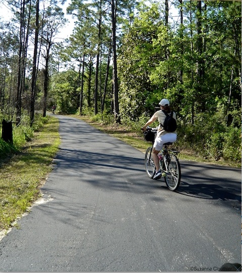
Between the beachside towns of Orange Beach and Gulf Shores
lies Gulf State Park (where, in
my previous post, we had gone fishing on the big pier). The park has six paved
paths – 18 kilometres in all – that are perfect for cycling, walking, or
jogging. They’re called the Hugh S. Branyon
Backcountry Trail.
Mr. Branyon was the park’s superintendent for
many years.

The paved
paths follow old logging roads, and even older trails that might date back
thousands of years: archaeologists have excavated First Nations sites within
the park.
We
spent a couple of hours peddling through oak and pine woods, listening to
birdsong, and exchanging warm “good mornings” with the many friendly people we
met along the way.

If
you get tired, you can sit on one of the many benches people have donated to
the park. Some were donated by birds! Heehee, not really – Canadians who go
south in the winter are often called snowbirds.


The
middle of Gulf State Park is alligator territory. I heard there are about 250 alligators there! I saw only songbirds, though, a big green turtle, frisky squirrels,
and a huge osprey nest, with Mama
Osprey perched right on it.

No
bears live in this park (we teddy bears stay in hotels instead), but about 300 black bears are known to live wild in Alabama. These
bears live mostly in Mobile County,
on the western shore of Mobile Bay. They like to eat the delicious honey
produced by titi plants (also called
swamp cyrilla). Titi plants need
marshy land where people are unlikely to go – a good thing from many bears’
point of view. Personally, I prefer having room service.
Leaving
your bike and climbing into a car, you can follow the Coastal Connection west,
past Gulf Shores, along Bon Secour Bay to the Fort Morgan Historic Site.
Fort
Morgan was completed in 1834, after the War
of 1812 inspired the U.S. to strengthen its shoreline defenses. During the American Civil War, the fort protected
Confederate blockade-runners. Union Admiral David G. Farragut got past Fort
Morgan during the Battle of Mobile Bay in 1864, though, and at one point in the
engagement is said to have shouted, “Damn
the torpedoes, full speed ahead!” Do pardon my language, but that’s
what the Admiral apparently said, and it’s become a really famous expression!

At the tip of the Fort Morgan Peninsula, you can board the
flat-topped, open Mobile Bay Ferry.

Several hitch-hikers came aboard with us.

The ferry took us across the shallow mouth of Mobile Bay,
dotted with natural gas drilling rigs, to a barrier
island called Dauphin Island.


Barrier islands are narrow, sandy islands, like giant
sandbars, that sometimes form alongside coastlines.
Next
to the ferry dock on Dauphin Island lies the Estuarium of the Dauphin Island Sea Lab. This is a public aquarium,
and part of a marine science research centre. The 10,000-square-foot Exhibit
Hall was busy with a class of high school students from Huntsville, Alabama on
a four-day field trip.


I
enjoyed the great exhibits, live tanks, maps, and informative posters as much
as I did watching the students (in matching T-shirts) work on a group
assignment.

Volunteers
manned stations to answer questions. I especially enjoyed speaking with an
older gentleman who showed me horseshoe
crabs. These are shelled cousins of spiders and scorpions, with eyes dotted
in weird places all over their bodies!

I
was also interested to learn that the vast estuary of Mobile Bay was a dry
river valley during the last great Ice
Age. Glaciers were so enormous during the Ice Age that sea levels fell hundreds
of feet. When the glaciers melted and sea levels rose, the Gulf of Mexico
drowned the valley of the Mobile River to create the modern-day bay.
After
a side-trip to the lovely Bellingrath Gardens, we headed north along the
western shore of Mobile Bay all the way to the edge of Mobile itself, and saw the city’s skyscrapers.
Crossing
a bridge to the eastern shore of the great bay, you can drive south through the
town of Daphne onto Scenic 98 (the eastern leg of the
Coastal Connection). We soon arrived in the charming community of Fairhope.

Suzanne
and I enjoyed an hour of shopping here, along with a cuddle and a purr from
a sweet Persian cat at the Christine
Linson Gallery. We bought a couple of Ms. Linson’s books that feature her felines,
Cat Tales: a Fairhope Adventure and Cat Tales II: a beach adventure.

Look – the cats autographed the books!

I tried to show my own feline room-mate, Audrey, the books
when I got home. Audrey, like many cats, likes to read through her backside …

Continuing
south along Scenic 98, we passed gorgeous homes on the shores of Mobile Bay. We
took a slight detour to see Magnolia
Springs, a small and very pretty community whose only postal service is
delivered by water. All the homes front onto the Magnolia Springs River, and
people’s mailboxes are all on their docks.

The
Coastal Connection returns you at last to Orange Beach, which got its name from
orange groves that were once planted along the beach. The coast here gets
enough cold winter weather that, in time, those groves didn’t succeed … but the
name, happily, remained. I was very glad to put the beach to its proper use.

Story © S. Clouthier
Coastal Connections map courtesy http://byways.org/explore/byways/2442/travel.html
Horseshoe crab photo courtesy Wikipedia
Mathew Brady’s photo of Admiral Farragut courtesy Wikipedia
Other photos © S. Clouthier
No comments:
Post a Comment